Since outreach began in April, the Irvine community has submitted dozens of draft maps for the composition of potential election districts in Irvine. With a total of 43 community-generated draft maps submitted, Irvine City Council Members on Tuesday, July 11, narrowed the total down to six focus maps, which will become the subject of two additional public hearings on district elections in September and October.
Dr. Justin Levitt, Vice President of the National Demographics Corp., said that he was impressed with the amount of feedback and community involvement he has seen in the map drafting process.
“We actually received, I think, more maps in this initial round than I’ve seen in a process before. We received 43 maps from the community — including five single district maps, five not population-balanced maps,” he said. “Then we have two more maps that have questionable legality, one of them only has three districts, that are each supposed to be for two members, and we have one map that is not reasonably compact.”
Of the 43 maps, Levitt explained that 13 of the submitted draft maps were unusable due to not meeting the state and federal criteria. In terms of criteria regarding state and federal requirements, districts within the draft maps must maintain an equal population of approximately 50,000 residents, have easily identifiable neighborhoods and be generally compact.
“Some of these require a good deal of discussion. For example, the Federal Voting Rights Act requires us to look at protected class communities, like Asian-American or Latinos — but it doesn’t require it,” he explained. “You must balance it with factors like communities of interest and neighborhoods – so, some of these require some engagement on whether or not a map is good in terms of meeting those requirements.”
For context, the term communities of interest is identified by the California Citizens Redistricting Commission as, “a contiguous population which shares common social and economic interests that should be included within a single district for purposes of its effective and fair representation.”
The Congressional Research Service defines the aspect of compactness as a district “that would tend to have fairly smooth boundaries, or resemble a standard geometric shape.” The agency adds that compactness is often used to combat gerrymandering during the redistricting process.
In preparation for the city’s upcoming public hearing on Tuesday, Sept. 12, Irvine Mayor Farrah Khan asked City Council Members to verbally list their three map choices, with reasoning.
With a total of 30 potential draft maps, the six district focus maps were selected by linking the common selection between each Council Member’s top three map choices.
While not yet finalized, Levitt explained that the six new focus maps create an opportunity to eliminate unwanted district concepts or expand on particular concepts of interest.
“If we don’t like a concept or think that a concept doesn’t work for Irvine, then it allows us to talk about several maps all together,” he said. “One of the things we can do, going into our public hearings in September and October, is really combine maps, put them together in different ways.”
Focus Maps in Detail
Map 126

District 1: The district bordering Irvine’s western edge, contains the UC Irvine area and Irvine Business Complex.
District 2: Bordered by California State Route 73 at the southern end and Interstate 5 near Irvine Spectrum at the east. This district includes University Park, Bommer Canyon, Turtle Rock, and the Quail Hill Open Space.
District 3: East of the Interstate-5, including Great Park, Portola Springs and Woodbury.
District 4: The district borders Irvine’s northern edge, includes California State Route 261 north through Orchard Hills, including Northwood Point.
District 5: This district is the central most district and contains Northwood, Cypress Village and Oak Creek.
District 6: West of District 5, containing Westpark, Woodbridge and Rancho San Joaquin.
Map 133
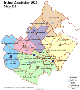
District 1: This district contains Westpark and Woodbridge in between Interstate 405 and Interstate 5.
District 2: The district borders Irvine’s western edge, contains the UC Irvine area, Irvine Business Complex, and Rancho San Joaquin.
District 3: Bordered by California State Route 73 at the southern end and Interstate 5 near Irvine Spectrum at the east. This district includes University Park, Bommer Canyon, Turtle Rock, Quail Hill and the Quail Hill Open Space.
District 4: This district contains Walnut near Interstate 5 and California State Route 261, Northwood at the northern border and Oak Creek at its southern border.
District 5: The northernmost district, contains Orchard Hills and Lower Peters Canyon, between the California State Routes 261 and 241.
District 6: The district on Irvine’s eastern border, with Interstate 5 at its western boundary. This district contains the Great Park, the majority of Cypress Village, Woodbury and Portola Springs.
Map 135

District 1: The district borders Irvine’s western edge, contains the UC Irvine area and Irvine Business Complex.
District 2: West of Irvine Business Complex, containing Westpark, Woodbridge, University Park and Rancho San Joaquin.
District 3: Bordered by California State Route 73 at the southern end and Interstate 5 near Irvine Spectrum at the east. This district includes University Park, Bommer Canyon, Turtle Rock, Quail Hill and the Quail Hill Open Space.
District 4: Bordered by Interstate 5 at the north, and Oak Creek at the South, this district contains Walnut, El Camino Real and Oak Creek.
District 5: South of Orchard Hills, east of Lower Peters Canyon, this district is north of Interstate 5, containing Northwood Point, Northwood and Woodbury.
District 6: Bordering Irvine’s northern edge, this district contains Orchard Hills and Lower Peters Canyon, and Portola Springs.
Map 136
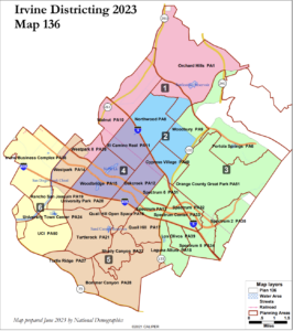
District 1: The district borders Irvine’s northern edge, includes California State Route 261 north through Orchard Hills, and Walnut.
District 2: Borders the southern edge of Orchard Hills, includes Northwood, Woodbury and a portion of Cypress Village.
District 3: The most eastern district, includes the Great Park, Portola Springs and the Irvine Spectrum. Bordered by California State Route 133 on its most western edge
District 4: Placed in between the Interstate 5 at its northern border and the Interstate 405 at its southern border, District 4 includes El Camino Real, Oak Creek and Woodbrige.
District 5: Bordered by California State Route 73 and the California State Route 133 to the West. This district includes University Park, Bommer Canyon, Turtle Rock, and the Quail Hill Open Space.
District 6: The district borders Irvine’s western edge, contains the UC Irvine area, Irvine Business Complex and Rancho San Joaquin.
Map 138
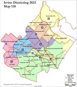
District 1: The district borders Irvine’s western edge, contains the UC Irvine area and Irvine Business Complex.
District 2: West of Irvine Business Complex, containing Westpark, Woodbridge, University Park and Rancho San Joaquin.
District 3: Bordered by California State Route 73 to the south, District 3 stretches west to the Great Park bordering Portola Springs.
District 4: Bordered by Interstate 5 at its northern end, this district covers El Camino Real, Walnut, Woodbridge and Oak Creek.
District 5: West of Interstate 5 in between the California State Route 261 at the east and the Great Park at its western border.
District 6: The district bordering Irvine’s northern edge, includes California State Route 261 north through Orchard Hills, and Lower Peters Canyon.
Map 144
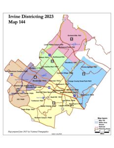
District 1: Located at Irvine’s northern edge, contains Orchard Hills, Lower Peters Canyon and Northwood Point.
District 2: Located at Irvine’s eastern boundary, bordered by Interstate 5 at its western border. This district contains the Great Park, Portola Springs and Cypress Village.
District 3: South of Orchard Hills, grouping Walnut, Northwood and El Camino Real with a portion of California State Route 261 to the west and Interstate 5 splitting its midpoint.
District 4: West of Oak Creek, bordering interstate 405 at the south. This district is home to Westpark II and Woodbridge.
District 5: The district borders Irvine’s western edge, contains the UC Irvine area and Irvine Business Complex.
District 6: Bordered by California State Route 73 and the California State Route 133 to the West. This district includes University Park, Bommer Canyon, Turtle Rock, and the Quail Hill Open Space.
Of particular note, Levitt pointed out that Map 144 was drawn and submitted by the city’s demographer — National Demographics Association — based on feedback from the City Council.
“Map 144, one of our NDC maps, is one of the only maps that has two majority Asian-American districts by citizen voting age population — it was something we wanted to show you,” he said. “There’s a broad variation. We’re not just trying to focus on that percentage, but we did want to show you at least one map that has two majority Asian districts.”
Levitt added that the boundaries in Map 144 divide about eight neighborhoods, whereas the other maps divide fewer neighborhoods.
In February, the Council agreed to add a measure to the March 2024 midterm ballot that would allow residents to vote on how the city conducts its elections process. Now, with two public hearings left, Irvine continues to encourage residents to submit feedback and suggestions, both in terms of community generated submissions on DrawIrvine.org, or feedback on the six selected focus maps.
If enacted by voters on the March 2024 ballot, district elections will expand the Irvine City Council from five to seven seats, and will also set district boundaries for city council candidates. The mayor’s seat will continue as an at-large appointment.
Currently, Irvine is the largest city in Orange County that uses at-large elections.
The upcoming public hearing is scheduled for Tuesday, Sept. 12 at 6 p.m.
Advertising disclosure: We may receive compensation for some of the links in our stories. Thank you for supporting Irvine Weekly and our advertisers.